In the 30th SPREP meeting held in September this year, the meeting supported the scaling up of environment data management in the Pacific and directed the Secretariat to initiate a process for developing a full-sized project proposal to support the scaling up environmental data management work in the region.
Later in October, the Inform Project participating countries collectively agree on the need to scale up and extend the Inform Project services beyond 2022.
The Pacific Network for Environmental Assessment (PNEA) Portal is an initiative of the Secretariat of the Pacific Regional Environment Programme (SPREP) to support government officials from Pacific Island countries and territories who work with environmental impact assessment (EIA), strategic environmental assessment (SEA) as well as Environmental and Social Safeguards (ESS).
The portal complements SPREP’s current capacity building program for EIA and SEA - including the recently launched Regional EIA Guidelines, the Coastal Tourism EIA guidelines, and SEA guidelines.
The dataset contains a range of different Pacific regional maps developed by the SPREP GIS team and is available for use by members and partners.
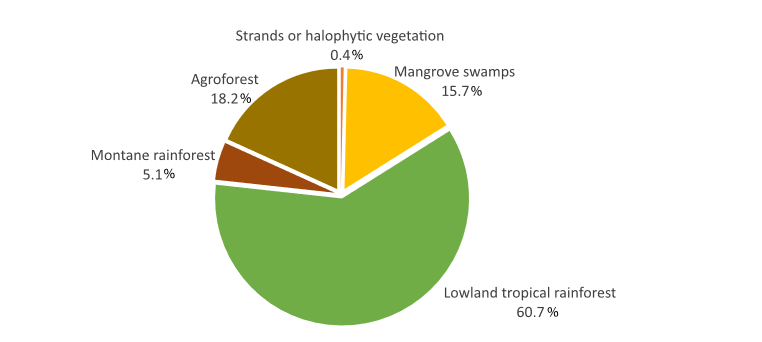
This dataset summarised a few key findings of the FSM State of Environment Report 2018 in interactive graphs.
In 2016, most of the 54,000 ha of forest in FSM was tropical lowland rainforest
Information on the location of known seabird breeding colonies throughout the Pacific including all PICTS, also Hawaii, Australian offshore islands and NZ Kermadecs
This publication is a companion piece to Island Innovations—UNDP and GEF: Leveraging Environment and Energy
for the Sustainable Development of SIDS, a joint UNDP and GEF (Global Environment Facility) book launched at the Third International Conference on Small Island Developing States, 2014.
This Wetlands of Wallis and Futuna 2017 inventory update builds upon the original Directory of Wetlands in Oceania (Scott 1993)
This study presents a “snapshot” of the current status of atoll biodiversity, including associated marine biodiversity, and stresses that atolls are “biodiversity cool spots”, which, apart from, in some cases, very considerable marine resources, have among the poorest and most highly threatened biodiversity inheritances on Earth.
Most atoll ecosystems and a wide range of terrestrial and marine organisms, and genetic or cultivars varieties of
traditional food and other multi-purpose plants are declining in abundance and under threat of either “economic extinction” or extirpation and in need of some form of protection. The severity of the situation is greatest on those more urbanized atolls where both the biodiversity and the local knowledge of biodiversity are threatened.
*see R Thanman pdf report for more information*
CVS version of the data in excel
Terrestrial and marine plants and animals that are rare, endangered or in short supply,
and in need of protection in the atolls of the Pacific Islands.
Disaster Plan for Chuuk State Government
The Dataset contains and will contain the following: • Updated text; • National R2R website or associated links; • Social media account names/handles – FB, Twitter, Instagram, Youtube etc; • Newsletters ; • Articles ; • Videos • Photographs • Resources – Concept/Technical Notes, Guides, Posters etc.